Bob Bunting brings his established credentials, including being a Director of the University Corporation for Atmospheric Research and a Lead Forecast for NOAA, to this guest commentary. He also mentions the Climate Adaptation & Mitigation Center (CAC), of which he is the CEO and which I personally support with money and effort.
We thought it timely to share Bob’s views as we in Florida start the summer red tide season and hurricane season with very warm water, even as we digest the newly released FEMA updates on disaster and contingency planning.
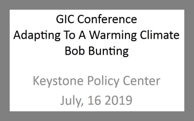
We thank Bob for this guest submission and also for agreeing to speak on July 16 at the joint GIC-Keystone Policy Center meeting in Keystone, Colorado. See: www.interdependence.org for details.
Editor's Update: Bob's July 16, 2019 presentation is available here - https://www.interdependence.org/resources/adapting-to-a-warmer-climate/
And his July 17, 2019 interview in Sarasota, FL can be viewed here:
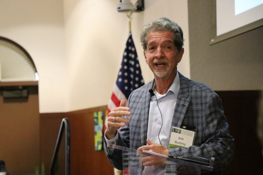
Now here’s Bob Bunting. -David
The Hurricane Season 2019 Outlook
By Bob Bunting
Hurricane forecasting has become more a science than an art over my multi-decade career, and that is a good thing! The last few years have not been kind to the US mainland and territories. In 2017, hurricanes Harvey, Irma, and Maria, all Category 4’s at landfall, caused massive flooding or wind damage; and last year, a slightly above-normal season in the Atlantic, was devastating, with two major hurricanes, Florence and Michael, setting records for wind and rain. These five storms traveled over very warm seas and had explosive development (ED) cycles, and Michael struck the panhandle of Florida as a Category 5, the first ever in the region.
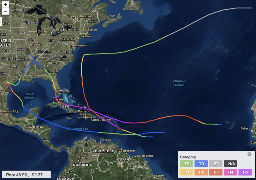
As I look at sea-surface temperature anomalies at present, I do not like what I see! In mid-June there are several areas where sea-surface temperatures (SSTs) are 3°C higher than normal, as you can see in the depiction below.
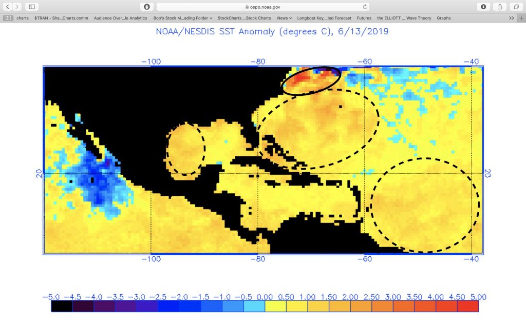
The coolest water, shown in shades of blue, is off the coast of western Mexico and in the northern mid-Atlantic. Warm water is abundant in the South Atlantic and along the East Coast of the US, as well as in the Gulf of Mexico along the Texas and Mexico coasts. The dashed ovals show SSTs that average 1 to 3 degrees C above normal. An area of very warm water, averaging 5°C above normal, lies along the Mid-Atlantic coastline from Cape Cod to North Carolina.
Three of the four areas of warmer than normal SSTs are therefore close to the US mainland and densely populated areas of our country. After the last several years, when we have seen hurricanes develop rapidly from the tropical storm stage all the way to Category 4 and 5 superstorms in just a day or two, we should be concerned! Incidentally, I have coined a term for such rapid development cycles: explosive development (ED).
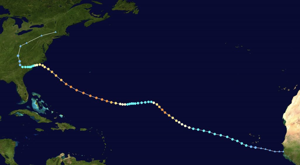
During the 2017 Atlantic hurricane season, Hurricane Harvey struck the Greater Houston area with peak winds of 130 mph and 60+ inches of rain in places. Then there was Hurricane Irma, which terrorized the Caribbean islands and Florida as it gained and maintained Category 4 and 5 status for days and proved to be the strongest Atlantic hurricane ever recorded. Finally, Hurricane Maria rapidly developed and whacked Puerto Rico with upper-Category 4 winds, leveling much of the island.
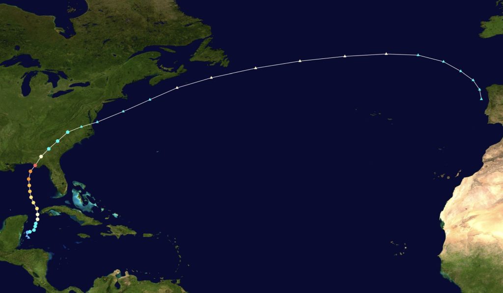
The 2018 hurricane season was active but with only two major hurricanes. Unfortunately, both of them hit the US. Hurricane Florence struck the Carolinas as just a Category 1 but drowned the area with 30+ inches of rain, a record for that region. Please note that the color-coding of the 2018 hurricanes is slightly different, but you will get the idea.
This is Florence:
Later in the season, Hurricane Michael ripped through the panhandle of Florida as a Category 5 storm.
Together, these five storms did an amazing $295 billion in damage, $265 billion in 2017 and $30 billion in 2018 and killed about 4700 people! Fortunately, last year the two major hurricanes hit the US in relatively sparely populated areas.
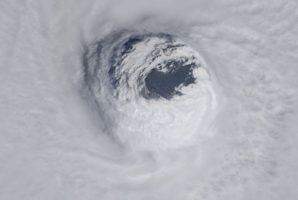
What is unusual about the last two seasons is that hurricanes experienced ED cycles where they intensified to Category 5 within a day or two. All these storms except Harvey had pinpoint eyes that were 20 miles or less in diameter. Take a close look at Michael’s amazing pinhole eye as it came ashore. When storms have this extremely compact eye formation, the winds around the eye are like large tornadoes that wipe the landmass clean. Hurricane Michael showed its fury as it leveled the area around Mexico Beach, Florida, and also mowed down more than a million acres of trees in North Florida and South Georgia. Inland Georgia experienced Category 3 winds for the first time in recorded history.
Two of the five storms, Harvey and Florence, dumped record rains as they stalled on the coastline. This, too, is unusual.
What we know is that SSTs are now much warmer than normal on average. When expansive water bodies like oceans and gulfs are warm, they also tend to warm to a greater depth than usual. When tropical systems move over expansive, warm water bodies they intensify more rapidly than they would over cooler water, all other things being equal. They also gather more moisture in the process and can become very heavy rainmakers, especially if they stall or move slowly as they approach land.
Since 1880, millions of verified observations have shown that the Earth’s average air temperature has risen by almost 2°F. That does not seem like much, but in effect it is! Warmer air holds more moisture. We also know that the poles are heating much faster than the equator is, which means the temperature gradient between the equator and poles is diminishing. When that happens, the jet streams weaken and move poleward. The result can be that hurricanes approaching the mid-latitudes can stall or slow down and dump those record rainfalls.
We also know that since 1880 sea level rise has averaged about 9 inches around the globe. When strong storms hit the coasts, storm surges are not only higher now because storms are stronger but also because the surges come on top of already higher sea levels.
So where do these considerations leave us as we consider the 2019 hurricane season? Thankfully, a weak El Niño event is ongoing in the Pacific. El Niño conditions in the Pacific correlate with stronger wind shear in the Atlantic. When the wind speed increases with increasing height, shear is created. Such conditions inhibit hurricane development by disrupting the vertical organization of storms.
Because we know SSTs are warmer than normal overall and wind shear may be somewhat higher than normal, the forecast is for a near-normal hurricane season this year. Normal is defined as about 12 storms total, with two or three major hurricanes. A major hurricane is considered a Category 3, 4, or 5 storm.
Given the normal season expected, why am I more than a little concerned? Because – and you may already see where I’m going here! – the warm SSTs are close to US shorelines, where tens of millions of people live. Thus, hurricanes approaching the US may spin up more rapidly than normal, as has been the case in recent years. Take Florida, for example. Since the 2000 census, Florida’s population has from grown from 15.3 million to 21.6 million today. Should a hurricane rapidly intensify just off the coast of a heavily populated area and then strike within 24 hours, there would not be time for an orderly evacuation. This is a nightmare scenario for planners and a potential catastrophe when it becomes reality.
With very warm water along the eastern seaboard well north of usual warm water anomalies of the past, this may be the year when a storm moving up the East Coast becomes much stronger faster and then maintains super-hurricane status for much longer than usual.
Why is this potential developing? We cannot say with absolute certainty that any particular storm is a result of climate warming. But what we can say is that much warmer sea surface temperatures create increasing probabilities of bad outcomes.
Climate warming impacts are here now Isn’t it time that we begin to plan, adjust, and mitigate the worst impacts of climate-induced changes like sea level rise and the changing characteristics of hurricanes? We know a lot about how to mitigate, plan, and adjust; but thus far our response has been too slow for the level of threat we now face. This just isn’t smart!
These are among the threats that have led to the creation of the Climate Adaptation & Mitigation Center (CAC). While the initial center will focus on local and regional climate-related issues in Florida, we hope the first CAC will be a prototype for other CACs worldwide to deal with local impacts. Adaptation and mitigation actions can help us to successfully deal with the worst impacts of a warming climate. While a global solution to the warming climate may evolve in the decades ahead, we now have little choice but to adapt in ways that protect our way of life. Climate warming is not only a problem for future generations; it is a problem for us! For more information about the CAC, please contact me at [email protected]. We need your help now!
David R. Kotok
Chairman and Chief Investment Officer
Email | Bio
Bob Bunting
Atmospheric Scientist, Author, Educator, and Entrepreneur
Email | Bio
Links to other websites or electronic media controlled or offered by Third-Parties (non-affiliates of Cumberland Advisors) are provided only as a reference and courtesy to our users. Cumberland Advisors has no control over such websites, does not recommend or endorse any opinions, ideas, products, information, or content of such sites, and makes no warranties as to the accuracy, completeness, reliability or suitability of their content. Cumberland Advisors hereby disclaims liability for any information, materials, products or services posted or offered at any of the Third-Party websites. The Third-Party may have a privacy and/or security policy different from that of Cumberland Advisors. Therefore, please refer to the specific privacy and security policies of the Third-Party when accessing their websites.
Sign up for our FREE Cumberland Market Commentaries
Cumberland Advisors Market Commentaries offer insights and analysis on upcoming, important economic issues that potentially impact global financial markets. Our team shares their thinking on global economic developments, market news and other factors that often influence investment opportunities and strategies.